Prairie State Conservation Coalition of Illinois is happy to announce the release of I-View — a free web-based application and viewer showing, for the first time, all natural lands protected in the state of Illinois.
I-View will significantly enhance the ability of conservation organizations, private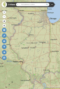 and public, to do conservation throughout the state. PSCC will own, operate, and update the site on a continuous basis.
I-View fulfills an identified critical need for accomplishing the goals of the state’s Illinois Wildlife Action Plan, Chicago Wilderness’ Green Infrastructure Vision, Grand Victoria Foundation’s Vital Lands Illinois, and other local and statewide initiatives that share the goal of establishing an interconnected system of Illinois protected natural lands and waters. With I-View, future land acquisition and current management can be coordinated across ownership categories for the first time at a landscape ecological scale.
I-View was made possible by grants from the Illinois Clean Energy Community Foundation (ICEF) and the Gaylord & Dorothy Donnelley Foundation, both based in Chicago, with support from the Illinois Department of Natural Resources.
The I-View team is composed of Angelo Capparella, associate professor, Illinois State University; Lisa Haderlein, executive director, The Land Conservancy of McHenry County; David Holman, GIS Consultant; and Gretchen Knapp, adjunct professor, Illinois State University. Holman did the bulk of the technical work assembling the data and producing the web-viewer site found here.
“We were particularly impressed by the aspects of the project likely to lead to on-the-ground results by assisting users to identify and protect important connections between existing natural areas,” ICECF Executive Director Dennis O’Brien said.
“Most important is the comprehensive and live nature of the data,” Craig Shillinglaw of Chicago’s Openlands said. “It will undoubtedly lead to more cooperation and identification of opportunities throughout the conservation community in Illinois.”
The majority of mapped lands, more than10,000 parcels, met three criteria: (1) natural or restorable to natural condition, (2) permanently protected, and (3) primary purpose as a natural area. Ownership categories include the coalition of nonprofit conservation land trusts represented by PSCC, the Illinois Department of Natural Resources, the Illinois Nature Preserves Commission, forest preserve and conservation districts, and others.
In addition to the maps, a click on any parcel reveals key data such as acreage, owner, etc. Other map layers provided can be layered to provide information on topography, watersheds, natural divisions and even legislative district. Especially important are the features enabling the creation of custom maps for a wide variety of purposes.
